AirNavigationPro
Air Navigation for Pilots
- 类型:旅行交通
- 平台:IOS
- 语言:多国语言
- 大小:216MB
- 时间:2023-04-14 21:14:59
- 包名:ch.xample.Airnav
- 版本号:8.3.195
- 厂商:Xample Sarl
- 官网:
相关推荐
此应用作品版权归属为原作者享有,应用信息来源于各大手机应用市场,请选择对应的应用市场进行下载,如此app侵犯了您的版权请提供相应的app资质,以邮件的形式联系本站,本站将积极的配合处理。


App截图
App介绍
AirNavigationPro是一款AirNavigationforPilots导航类型的app,为您提供最新AirNavigationPro官方IOS版下载。
LESSTIMEPLANNING,MORETIMEFLYING
-Everythingyouneedtoflyaroundtheworld
-Planyourflightwithinminutes
-Flyrelaxedwithupdatedandliveinformation
AirNavigationProisahigh-qualityflightassistantappwithrealtimeGPSnavigationandflightplanningfunctionsforprivateandprofessionalpilotsallovertheworld.Youwillprofitfromthefollowingmainfeatures:
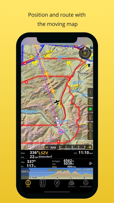
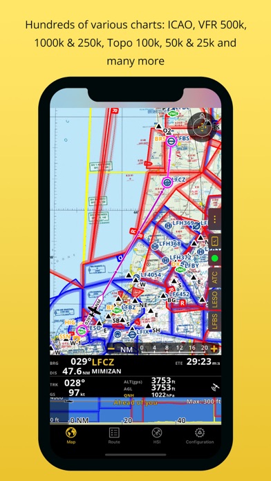
MOVINGMAP&FLIGHTPLANNING
TheMovingMapdisplaysaeronauticalchartsasbackground,whileontopinteractivewaypoints,airspacesandyourplannedroute.PlanandedityourroutewiththeFlightPlanningfunction,directlyfromthemovingmaporbysearchingthewaypoint’sdatabase.Theplannedroutewillbedisplayedonthemovingmaptogetherwithfurtherinformationsuchasnextpointdistance,track,headingandmanymore.
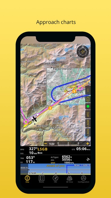
APPROACHCHARTS
Thegeoreferencedapproachchartsaredesignedformaximumvisibility.Displayingnowalsointhe3Dview,theyprovideincreaseawarenessofyoursurroundingsduringtake-offandlanding.Also,createarouteandAirNavigationProwillinstallrelatedapproachchartsyouneedforyourflightautomatically(ifpartofyoursubscription).
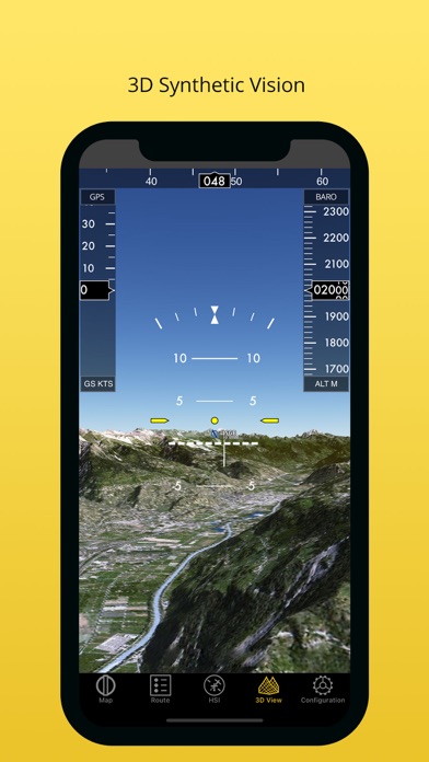
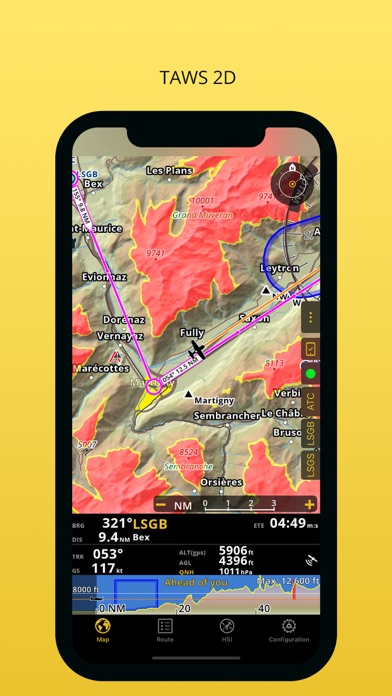
AERONAUTICALCHARTS,PROFILEVIEW&3DVIEW
WeprovideaworldwideselectionoffreeandpaidchartsincludingthemainICAOcharts.TheProfileViewgivesallterraininformationforbettersituationawarenessandsafetyenhancement.The3Dviewprovidesenhancedterrainawarenessandiscompatiblewithgeoreferencedapproachcharts.
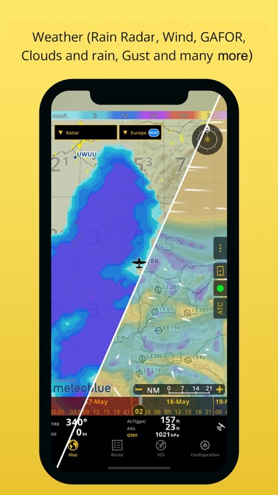
WEATHER(includedinallPremiumandSmart+subscriptions):
Reviewweatherforecastforupto3daysahead!Youwillbeabletoseeontopofthemovingmap,thefollowingdata:RainRadar,Wind,Pressure,Cloudsandrain,Visibility,GustandGAFOR(CH&DE).Createyourflightbriefingsincludingweatherchartsandgraphs.Weatherdataareupdatedevery24hourswitha1hourinterval.
INSTRUMENTS,ALERTS&TRAFFICAWARENESS
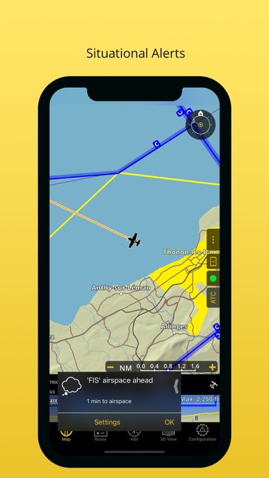
SimulateaircraftinstrumentsusingtheinformationfromGPSandothersensors.Setawiderangeofalertscustomizedtoyourneeds,forexampletonotifyyouwhenatargetaltitudehasbeenreachedorabandoned.
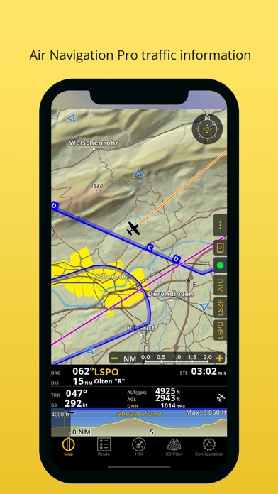
EnhancesafetywiththeTrafficAwarenessfeaturebydecreasingtheriskofacollision,flysimultaneouslyorfollowanotheraircraftthatyoumarked*
*requiresGSMinternetconnectionoranexternaldevice
DATABASE&SEARCHENGINE
Globalaeronauticaldatabasewithover200.000waypointsand50.000airspacesconstantlybeingupdated.Searchandnavigatetospecificlocations.Alsocreate,editandexportcustomwaypointsandroutes,aswellascreateaircraftprofilesforbothhelicoptersandairplanes.
AUTOMATICLOGBOOK,FLIGHTPLAN&BRIEFING
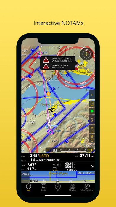
TheLogbookusesGPSinformation,plusit’sautomaticandfullyeditable.Itcanbesharedviaemailorviatheintegratedwebserver.Createdifferentfiles,liketheOperationalFlightPlanortheNOTAMBriefing,whichwillhelpyoutodocumentyourflightandtofollowyourplanasyoucommunicatewithAirTrafficServices.InteractiveNOTAM,whichwillautomaticallyappearonthemovingmap,arenowincludedinourpackages.
LIVETRACKING&FLIGHTRECORDING
Followyourflightinrealtime,recordyourflight,replayandanalyzeyourtrace.TherecordedflightcanalsobeexportedasKMLfileandbeviewedonGoogleEarth.
ADDITIONALFEATURES
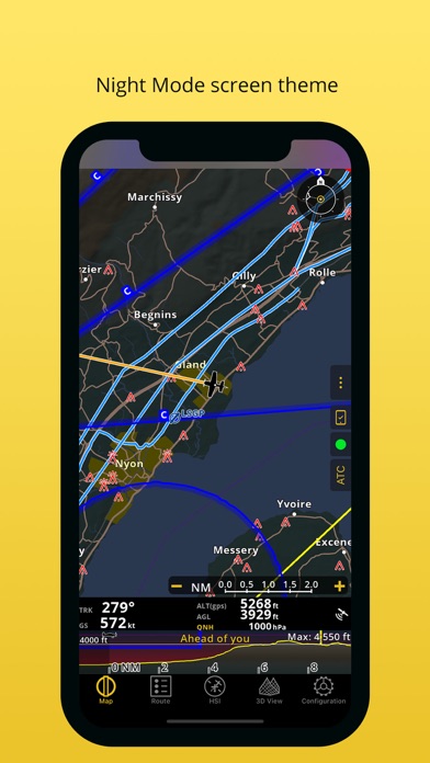
MovingMapoptimizedfordayandnightoperation
WeightandBalanceComputer
Supportsexternalsensors
Andsomuchmore...
REQUIREMENTS
iPads“WiFionly”don’tincludeaninternalGPSreceptor,anexternalsensorisneededforthesedevices.CheckoutourUserManualonourWebsite:www.airnavigation.aero
对AirNavigationPro有什么评价可以在下方的评论中和大家分享。如果是其他问题可以直接联系AirNavigationPro的官方。
热门用户评价
用户用户1545646543794评价:突然变成免费的了,地图数据依旧无法下载
用户了不起的挑战!缓解疲劳驾驶习惯评价:己购买一年,不能下载中国区地图。盼解决。
用户Jokertffk评价:中国区无法下载地图刚买几天就免费了
用户kennyvip评价:把软件改为英文版就可以下免费地图了中文版下不了的
最近更新
*Improvedelevationprofile:moreinformationandfunctionalities
*Windbarbsonmapandelevationprofile
*ImprovedNOTAMdisplay
*Stylingofdynamicairspaceswillnowchangedependingtheirstatus
*Trafficpatternsarenowdisplayedonthemapforselectedcountries.Moretocomesoon.
*SmartChartimprovedtodisplayworldwideforests,build-upareas,glaciersandmore
- Love Live! 学园偶像祭秋季庆典礼包活动 2019-10-09
- 小鸡庄园今天答案最新正确答案2022-小鸡庄园今天答案412 2023-04-11
- 有助于保留紫薯中的花青素的烹饪方式是蒸还是水煮 2023-03-24
- cctv6电影频道今天播放的节目表-电影频道2023年3月19日节目表 2023-03-19
- 414蚂蚁庄园答案最新-蚂蚁庄园就地取材土菜精做 2023-04-14
- 少年西游记天界宝库-神山挖宝活动 2019-10-03
- 蚂蚁庄园今日答案410-2023年蚂蚁庄园今日答案最新今日已更新 2023-04-10
- 小鸡答题今天的答案4月12日-小鸡答题今天的答案是什么 2023-04-11
- 方寸对决侠玩下载攻略-侠玩助手怎么下载方寸对决 2023-03-24
- 小鸡宝宝考考你清明时节的传统习俗 2023-04-05
- 神奇海洋今日答案314最新-考考你哪一种海鸟俗称呆鸥 2023-03-14
- 红薯晒干后会发白-晒干的红薯干有一层白色的 2023-03-27
- 悬赏猫怎么发布任务 2022-11-17
- 庆余年2回归角色曝光-庆余年2将回归的角色 2023-03-30